The Cave Mapping Adventure – March 2017 – Systema Aktun-Hu – Tulum, Quintana Roo, Mexico
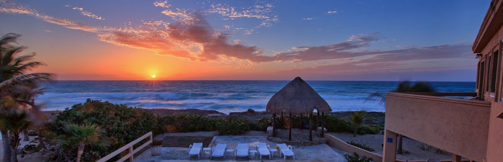 |
| Sunrise-Half Moon Bay, Akumal, Quintana Roo, Mexico-Photo: Alberto Nava |
After having removed over 8 feet of snow from our driveways in Reno, Nevada, USA, since January First 2017 and enduring 3 flooding events within our home, my mental state came to a head with interned frustration about the 23 of February. Being a wise and supportive soul mate, Kim took one look at me and said, “you need to go diving!”, “get out of here as you are driving me nuts and are doing yourself no good.” Well, with those words said, it took me a whole 5 hours to organize and book a trip to the caves in Mexico.
I had started putting out feelers to my global dive pals and I knew if someone was in Mexico, I could probably make a cave diving trip happen. I contacted my good friend, Alberto “Beto” Nava of the Bay Area Underwater Explorers (BAUE) to see what he was up to. Turns out, he was in Mexico and needed a dive buddy to do some work in one of the cave systems he has been working on since 2007.
Bags packed (200lbs in 4 pieces), away I went, at the airport 4:30am, 1 March! I really had no idea what we were going to do as thorough communication in these situations is never really…thorough! What I did know, is that I was going to dive with my JJ (closed circuit rebreather: CCR) irrespective of the weather here or there! The last diving I did was in Lake Huron in November and if you followed my reports, you know how that was…cold, windy, subject to extreme water conditions and 35 feet of visibility.
Landing, I had never encountered so many travelers. Customs was packed like a “can of sardines.” Took me 2 hours simply to get through customs but by 8 pm I was in Tulum at the Hotel Tulum Inn and organizing gear for the next 4-5 days.
2 March, I met Beto for breakfast at a little palapa on the main highway of Tulum, we had breakfast tacos and discussed the plan. Here is where I got real excited. In 2007, doing a dive from the cenote La Virgen, some 3000 feet to the south, Beto and his team found Hoyo Negro, a underwater pit approximately 200 feet (60 meters) in diameter and 190 feet (57 meters) deep. Over the next several years, they would find things in Hoyo Negro that blew science, researchers, archaeologists and the world away! I will let you do your own research with these links:
- Hoyo Negro – A Submerged Late Pleistocene Cave Site inQuintana Roo
- Proyecto de Espeleología de Tulum (PET)
- Instituto Nacional de Antropología e Historia (INAH)
Now you have some background and the plan was to continue working in this system, Aktun-Hu, with the goal of continuing the map survey work but on some leads (existing lines) in very difficult locations. We spent the day getting gear assembled, tanks filled and familiarizing me with the process of “underwater map survey” techniques. I was amped as I love working underwater.
3 March, we made the 8 km (5 mile), 25 minute drive into the jungle and arrived at cenote La Concha (images on the New Millennium Dive Expeditions,Facebook page). Entering the water we traveled about 1500 feet (450 meters) to our first line CU21. Our goal was to get accurate information on this line.
Each line has an “initial” base tie-off point. This would be considered “Station 1”. Each place where the line is physically tied to the cave, be it on a rock of solid position, a stalagmite or some other sturdy cave feature, a cave line station is created; goal… to gather data at each station.
The first task at each station is to gather depth and compass coordinate (azimuth) information; coordinates are obtained directly on the station from the line leading into it and from the line leading away. The photo below shows Beto gathering this information –
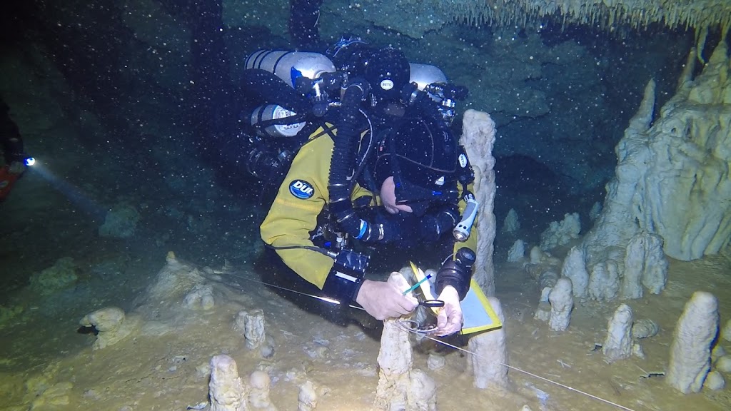
The next step is to notate this information in a notebook containing waterproof paper and yes…using a regular pencil. The photo below shows Beto recording this data –

Once this data is recorded, then an accurate measurement from station to station is obtained. The photos below show (top) Beto beginning to reel out the measurement tape and Sam behind holding the measurement tape, and (bottom) Sam reading the exact measurement between stations. –


We “leap frog” from station to station gathering all this data and when we get to the end of the line, we exit the line, go back to Station 1, and prepare for the next phase of the line survey; measurement of cave width from each station, left and right.
During cave width measurement, we begin again at Station 1, one diver maintains position at the station and utilizing either the measurement tape or an underwater distance sonar or both, the second diver moves to the left or right, aided by an underwater laser pointer. This laser pointer puts a point on the cave wall that looks like the furthest away from the station. A measurement is taken at a point where the diver can safely, without damaging the cave, move to. If the cave width is further than that diver can safely maneuver, then the sonar is utilized and both measurements are input onto the data sheet. This is done on the left side of the station and again on the right side of the station and continues to the end of the line with this procedure duplicated over and over.
Once all this is done for a line like CU21, we exit the water with data sheets as depicted in the photo below.

Once out of the water and back at a computer, those data sheets are meticulously input into mapping software creating a stick map and then a topographical map.
The image below shows line PRA28 (yellow) which we surveyed and was my favorite line of this adventure. Curvy, tight, highly decorated and very intricate; a line we surveyed up to a restriction that we did not feel we could continue through with our existing equipment configuration. If you look closely at the image you can count the some 30 plus stations surveyed.

This image shows the stick map being enhanced to a topographical map showing cave widths [Note: this image was not from one of the lines we surveyed]. It is provided for a visual understanding.

It was an exceptional trip! During my 4 days of diving, we surveyed 8 lines and spent a bit over 15 hours underwater; Beto…thanks for the snacks during our dives. Our max depth was only about 45 feet (14 meters) so decompression was never an issue. I came away with a new understanding of the cave systems that I have been diving since 2001.
BUT…lets put some perspective to all this. During my 4 dives and 8 lines surveyed, I would say that we surveyed about 1000 feet (300 meters) of line. There is estimated to be 121,000 feet (36,300 meters) of line within the Aktun-Hu cave system and Beto? Beto and his team have surveyed over 51,000 feet (15,500 meters) in efforts to create one of the most detailed and complete maps of this system ever! THAT IS ALMOST 10 MILES OF SURVEY WORK!
I was proud to support this massive effort in the small way that I did. An effort that you will understand, if you can do the research from the links that I provided, is critical to protecting this system that was the resting place of Naia!
4,5 & 6 March were much the same as we dove each day with the intensity and vigor as each day prior. However, it was not all work, there was a lot of dive time in between lines and time for image therapy. So here are a few. I will be putting together a 3-4 minute video of these dives and it will be posted on our New Millennium Dive Expeditions Facebook page in the near future.
Thanks for following the continuing adventures of New Millennium Dive Expeditons, its Project Baseline and Project Baseline: Lake Tahoe endeavors and myself. Here are some photos with captions for you to enjoy…
 |
| Insane “decoration”. These caves filled with H2O about 23,000 years ago…how long do you think it took for these formations to form? Puts you in a position of direct respect for Mother Nature! |
 |
| Draperies of calcite flows ending in stalactites. |
 |
| Just overwhelming!!! |
And last but not least…one of me –

Until next time, be well and if you are not a diver, become one. If you are a diver, dive often, dive safe and always, DIR!
 Previous Post