New Millennium’s, Project Baseline Lake Tahoe has an incredible day at the lake. 26 September 2015
It was a great day on Tahoe both from the production standpoint as well as the weather. NMDE divers Marc B. and Martin M. launched the boat from Cave Rock (one of 3 remaining launches around Tahoe) and were headed to Hurricane Bay by 7:30 am in anticipation of accomplishing quite a “task” filled agenda.
The day’s agenda was made possible by a Grant from the Nature Fund that is managed by the Tahoe Truckee Community Foundation. Before we continue with our report we want to thank both organizations for their dedicated involvement and environmental support of Lake Tahoe and for giving us this opportunity to share what is happening underwater around the lake.
To begin, the culmination of this days 4 dives and some 7 hours on the lake is most aptly shown in this photo collage:
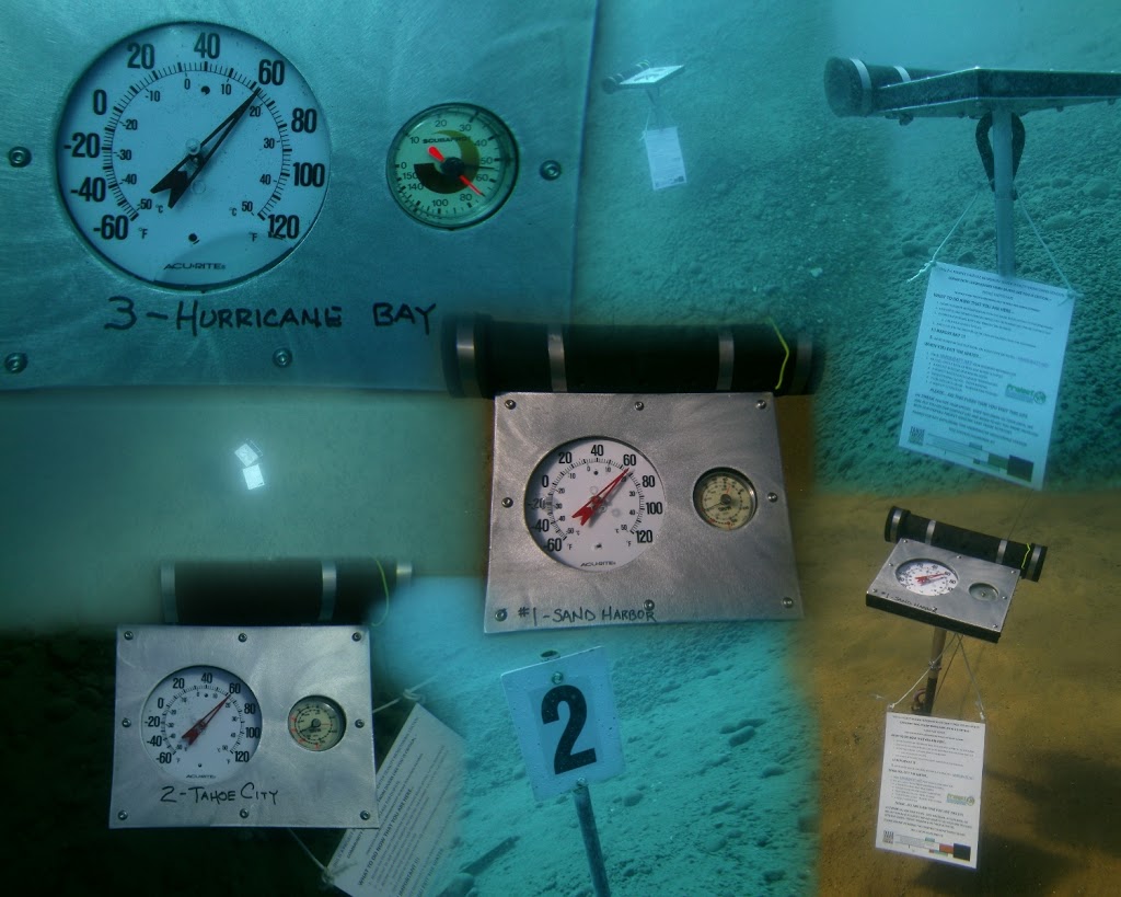 |
| This photo collage shows all three Nature Fund sponsored stations in the Northern Tahoe area. Set and ready for data collection. |
The plan for the day was to establish a new station in Tahoe City, upgrade both the Hurricane Bay and Sand Harbor stations, clean the visibility markers & realign to the benchmark at each station and finally, to remove the old station at Carnelian Bay (as our main point of interest there was removed and the boat traffic is much too dangerous to have a station there).
In July, NMDE submitted a Grant proposal as mentioned to the Tahoe Truckee Community Foundation for the Nature Fund. In late August we were notified that we were successful and in September we received our Grant Funds. We immediately went to work; winter is coming and we wanted these stations in place. This Grant focused upon Sand Harbor, Tahoe City (New) and Hurricane Bay. In order to accomplish this task, we had three new depth/temperature board constructed, purchased the digital depth/temperature sensors, built the underwater containers for the digital sensors…well, a picture is better:
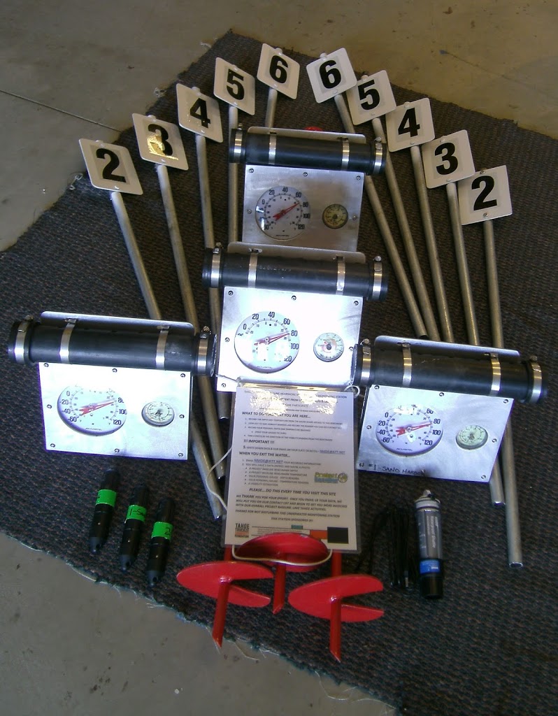 |
| This is the compliment of “stuff” we had to make for this weekends diving – enough said! |
The digital sensors arrived on 21 September- we call them our “minions” of depth and temperature, which allowed us to put everything together and schedule our dive day for the upcoming weekend.
 |
| The three Onset digital sensors and the Shuttle that launches them from the PC. |
Our first stop was at Hurricane Bay, about a 40 minute boat ride on “glass” flat water from Cave Rock across the width of Tahoe as Cave Rock is on the east shore and Hurricane Bay on the West. A cool morning with partly cloudy skies. After launching our digital sensors (done with a PC and specialized software) at the lakes atmospheric level (11.8 psi – a high pressure ridge was present as the standard pressure at Tahoe is 11.66psi) we sealed them up and placed them in the underwater containers we built for them:
 |
| Not very high-tech but workable and “affordable” for a Non-Profit organization |
Once all our equipment was ready, we geared up and entered the water. Here at Hurricane Bay, we already had a station established so this site was simply to receive the new station gauges with the digital sensor, the instruction placard and a cleaning of the visibility markers. This dive would be less than 30 minutes to a depth of 55 feet. Here are two photos of the old and new stations (you can see that the new stations are easier to read from top down and have a larger and easier to read temperature gauge):
 |
| OLD |
 |
| NEW |
Today’s benchmark readings for Hurricane Bay were 54 feet of depth with about 30-35 feet of visibility at a temperature of 62F.
Stop two was just up the road and into Tahoe City where Tahoe used to flow into the Truckee River – it presently does not as the lake is easily 2 feet below its natural rim of 6223 feet above sea level and down almost 8 feet from its high water mark of 6229 feet above sea level last seen on 28 June 2006. Here we will establish a completely new Project Baseline: Lake Tahoe monitoring station. As we approached the area we thought we would place the new station, we were astounded as the depth was only 4 feet. We then traveled due east (090) for about 3/4 of a mile where we got to a depth of about 20 feet and decided this is where we would place the station. We really wanted the station to be closer to Commons Beach so that divers from the shore could visit and monitor but it simply was too shallow. We again assembled all our station materials and lowered them over the side, geared up and entered.
Once on the bottom, boy were we in for a workout! The bottom here was rock, all rock! Just driving the auger into the bottom took 30 minutes, half our remaining gas, and at that, we were only able to drive the 48″ auger about 16″ into this bottom:
 |
| The “milky” cloud came after about 8 inches in depth to a new layer of probably clay. |
Placing the visibility stakes was no easier and swinging a 5 pound sledge hammer underwater is a lot harder than it sounds! But we persevered and after one hour we had the Tahoe City station established. Its coordinates are N 39′ 09.924 W120’07.860 so if ever you are out there in your boat and your dive gear and your GPS, please visit, record and send us your readings to nmde@att.net!
Today’s benchmark readings for Tahoe City were 17 feet of depth with about 30 feet of visibility at a temperature of 64F.
Next stop was up to Carnelian Bay where we were going to remove all our existing station equipment. The reason we established Carnelian Bay in 2012 was because there was a 25 foot long concrete fish placed there in the early 2000’s. This made a great dive feature and we put a line along the bottom leading out to it so divers could easily visit this site and help us record and monitor the changes in the lakes depth, temperature and visibility. Well…I guess those that placed it there, decided that they no longer wanted the potential attention our station was bringing to it and I guess the potential negative impacts they might incur should there be an illegal dumping investigation so they replaced it. They did not remove it from the lake however, as we saw the drag marks along the bottom they left when they moved it to deeper water. We have not found its new location yet but we will – unless they put it in water deeper than 300 feet. But for fun, here is a now “historical” photo of the Carnelian Bay Fish:
 |
| Fish located by divers in 2003 and removed in 2014 – too bad, it was a fun dive. |
This was a 10 minute dive as we simply dropped down to 30 feet and removed everything; easier to take this stuff out than put it in. Put it on the boat and headed over to Sand Harbor.
Once at Sand Harbor, its depth/temperature board already removed (we wanted to maintain consistency of analog gauges at this site – Hurricane Bay’s was broken and Tahoe City…new) we simply dropped down, put in the new board and gauges along with the instruction placard (which we hope will increase participation by the sport diving community),cleaned the visibility markers and our dive day was complete. Surfaced, exited, geared down and relaxed while having some lunch and beverages. A truly great day. We had to navigate some rough water from the Whittell Mansion south to Cave Rock but managed to get off the lake by 3 without incident.
Summary for this day: 4 dives, 3.5 hours of runtime on the NMDE research boat, 3 stations completely established and upgraded ready for monitoring and recording and 18 man hours of volunteer time added to our log. What a great day!
We are presently in the process of applying for two more Grants as we still have 5 more stations to upgrade and or install – upgrades at Bliss (yes we just installed but did not have the funding for the digital sensor) and Glenbrook and then new stations at Camp Richardson, Tahoe Keys (that should be informative) and Nevada Beach. Presently we are trying to raise another $650 to purchase two more sensors so we can do Glenbrook and Bliss before winter. We welcome donations, they are completely IRS tax deductible [NMDE tax ID – 88-0481587] so if the opportunity presents itself, please let us know – nmde@att.net.
In closing, as one of the 5 remaining Founding members of NMDE, I want to thank my most relied upon member, Marc B. for having always been there in support of our expeditions and research. Without him, this weekend would not have been possible. Thank You Marc!
Remember to “Like” – New Millennium Dive Expeditions on Facebook – This is where our original posts and notifications begin. Love to see you there. Thanks
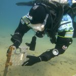
Some additional photos, Enjoy…
 |
| The instructional placard on all stations |
 |
| Heading back to Cave Rock |
 |
| Marc supervising my work at Hurricane Bay – The Alley Cat below him |
 |
| A beautiful Fall Tahoe Day |
 Previous Post
 Next Post