NMDE – Re-establish the benchmark at Patton Beach
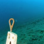
Today NMDE divers Vanessa Belz and Martin McClellan ascended upon Patton Beach in Carnelian Bay on Lake Tahoe’s north shore (39.22624,-120.07979) – also now known as Watermans Landing. In May of this year we established the benchmark in 37 ft directly in front of (north) the Patton Beach Fish – a 20 foot long, 8 foot high concrete fish that was discarded by the miniature golf course across the street prior to 2004 – when we first found it. Sometime between May of this year and 9 November, 2013, someone decided to remove the benchmark and line leading to the fish and place all the equipment in about 15ft of water and leave it there. At least they did not take it. This equipment was found by another local diver and returned to us.
Today, our goal is to reestablish the benchmark, and place additional line leading to the site. The reason for the line is that the bottom composition of Patton Beach is basically featureless and since the fish is approximately 1200 feet from shore, it is a tough navigation and we wanted to make visiting our Project Baseline: Tahoe [http://projectbaseline.org/projects/usa/lake-tahoe] site easier.
We scooted out on the surface to the approximate area and because the visibility was very good on this day, we were able to locate the fish very expeditiously as it sits in approximately 35 feet of water. We descended, re measured the location of the benchmark and placed the 8″ diamater auger back into the bottom about 16 inches. This should hold. Interesting where the benchmark was placed was an obvious pit in the bottom about 18″ deep and about 3 feet in diameter. Someone really had to work this out of the bottom so we hope that does not occur again. Once the benchmark was placed, we assessed the depth, 35ft per the gauge on the benchmark and 56 degrees F on the temp gauge (this compared to 31feet on my digital gauge and 52 degrees F) – the difference is the gauges on the benchmark are older, analog for the depth gauge and a simple outside thermometer for temp. After noting depth and temperature we assessed visibility which was at least 30feet but not 40feet. We can tell this as we have visibility markers placed every 10feet starting at 20 feet from the benchmark. If you can see the 3, which is 30 feet, which we could, and we could not see the 4, which is 40 feet, this gives us our visibility reading. Importantly this is the exact same for any diver visiting the site keeping the information collected for Project Baseline: Tahoe, scientifically valid. Finally, we took our photo of the fish and then began the process of laying line.
After attaching our line to the depth benchmark and providing a secondary tie-off, we headed 300 degrees to the nearest boat buoy. We then ran the line directly into the beach at about 340 degrees along the debris field of old boat buoy anchors which consist of old concrete beams, motor blocks, 55 gallon drums filled with concrete, etc. and lots of old boat parts. We made kind of a nice debris pile to debris pile type of course. Fun to dive and stuff to see.
Our dive was 83 minutes to a maximum depth of 35 feet with an average depth of 18 feet. We saw no invasive plants or animals but encountered a fish cleaning station, right at the Patton Beach Fish, where fishing operations from the Marina adjacent to this site stop to clean their clients fish. Thus, we saw lots of crayfish…bring a bag as we are certain that the local sportfishing companies know of this concrete fish.
PBTahoe Stats:
Depth: 35 feet
Temp: 54f
Visibility: 30-40 feet
Photo:

 Next Post